TDG Gold Corp: Shasta Mine Complex Geophysics Confirms New Targets
White Rock, British Columbia, October 17, 2022 – TDG Gold Corp – (TSXV: TDG) (the “Company” or “TDG”) is pleased to announce the results and interpretation from the 100 line-kilometre (“km”) of high-resolution ground-based magnetics and Very Low Frequency (“VLF”) survey work over the Shasta Mine Complex.
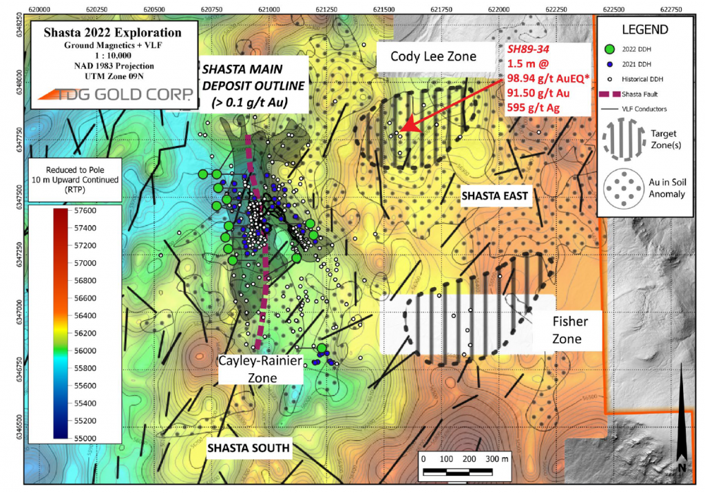
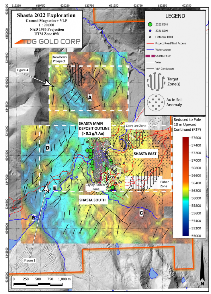
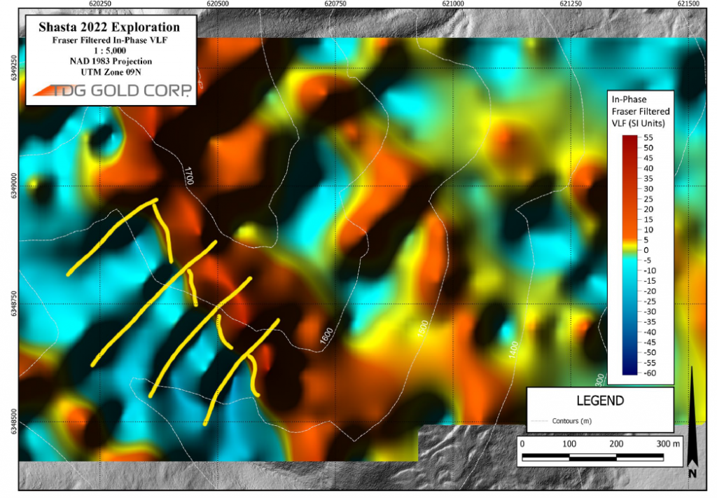
The results suggest multiple, strong structural anomalies contained within a ~4 km x ~3 km area surrounding the Shasta Deposit. The anomalies coalesce into clearly defined target zones including the recently renamed “Cody Lee” and “Fisher” Zones (see Figure 1) which are both located to the east of the Shasta Deposit; and the previously reported Newberry Prospect located ~1.5 km north of the Shasta Deposit.
The results from the geophysics complement information from historical drilling in the Cody Lee and Fisher Zones and soil sampling programs across the Shasta Mine Complex. For example, diamond drillhole SH89-34 in the Cody Lee Zone which intercepted 17.1 metres (“m”) of 3.37 grams per tonne (“g/t”) gold (“Au”) and 45 g/t silver (“Ag”) [3.94 g/t AuEq*] from 27.9 m depth; including 0.5 m of 91.5 g/t Au and 595 g/t Ag [98.94 g/t AuEq*] from 43.5 m depth.
This work represents TDG’s next step towards identifying priority drill targets for 2023, as well as determining the ultimate potential of the Shasta Mine Complex; and if indeed the Shasta Deposit is actually part of a bigger related mineralized system.
RESULTS & INTERPRETATION
The technical work completed to date also incorporates historical data and information undertaken by past operators including Newmont – which made the initial Shasta discovery in 1983 and identified additional targets at the time. Epithermal deposits such as Shasta commonly occur in clusters.
The geological/geophysical results indicate consistent apparent offsets of the main north-northwest feature by northeastern trending features that TDG interprets to potentially be faults and which have typically hosted the higher-grade mineralisation drilled at Shasta. Of particular interest are new structures identified at TDG’s Newberry target (located ~1.5 km to the north-northwest of the Shasta resource); in the East Shasta area at the Fisher Zone and Cody Lee Zone Prospects; and also at Shasta South where it appears the trend continues south of the Cayley-Rainier Zone (Figure 2). These structures differ from the historical mapping interpretation of previous operators, including Newmont. This could lead to a new interpretation of Shasta as a cluster of related epithermal lenses (“string of pearls”) covering an area ~4 km x 1 km and which may or may not have structurally connectivity and integrity.
Chris Dail, a consultant for TDG’s regional exploration program, commented, “The ground-based magnetics and VLF survey completed in September 2022 is the first step to try answer the question: how big could the Shasta Mine Complex be? Work by Newmont in 1983 after the initial Shasta discovery, clearly identified multiple opportunities that they recommended for follow up but were not. We also recently completed a large soil sampling program over the Shasta Mine Complex to verify historical data, fill in gaps and extend known anomalies. Combined with our recently completed geophysical surveys, we expect to identify multiple new drill targets. It is rare to come across areas with such widespread mineralization of the character observed in and around the Shasta Deposit as well as numerous poorly and untested anomalies. The ability to develop a pipeline of drill targets bodes well for future discovery opportunities on the project.”
Steven Kramar, TDG’s Vice President, Exploration, commented, “Chris Dail’s expertise and development of our regional exploration program has given us the opportunity to execute two separate but parallel technical teams: Chris’ team has reviewed historical data and collected and integrated new, high quality information to develop our pipeline targets to a drill decision in 2023; meanwhile the Shasta resource team continues to stay focused on testing and growing the known Shasta resource. This strategy has been effective and successful, and we look forward to a busy 2023.”
PROGRAM SUMMARY
This year’s exploration program focused on generation of additional data to support future drill targeting in the immediate area around the Shasta main Deposit, in the broader area of the Shasta Mine Complex. Work included: i) detailed structural analysis of exposures in historical trenches, roads cuts, open pits and outcrops east of the Shasta main Deposit that will be integrated with the oriented diamond drill core from last year’s drill campaign and our ongoing program, ii) soil geochemistry and, iii) ground geophysical surveys.
Emphasis during field work this season was on structural analysis focused on obtaining trends and cross cutting relationships between different vein events. Observations of vein offsets by structural elements will facilitate more detailed and reliable block modeling of the Shasta main Deposit and provide information for prediction of favourable trends and orientations.
TARGET GENERATION In the late 1980s and early 1990s past operators completed large soil grids and VLF and VLF apparent resistivity surveys using older Geonics EM16R VLF survey receiver instruments over portions of the property and identified several targets based on the results. Many, in fact most, of the identified targets were never drill tested. A few were and led to successful identification of mineralization which was the partial focus of this year’s field exploration activities.
The Fisher Zone (formerly called O-Zone), located approximately 600 m southeast of the Shasta main Deposit (Figure 1) consists of a broad ovoid area, approximately 350 m x 500 m across. The area has limited outcrop and bedrock is situated beneath a thin veneer of glacial-derived sediment cover. A total of seven shallow, small diameter, historical diamond drill core holes, totalling approximately 817 m, were drilled beneath the shallow overburden to test EM16R VLF geophysical anomalies and intersected widespread disseminated gold and silver mineralization over 20-30 metre (“m”) thick drilled intervals (Table 1). Our VLF surveys from this season indicate this mineralized prospect is along a series of northeast-trending conductive zones defined by our Fraser filtered VLF. The area of anomalous precious metals in bedrock and the VLF conductive zones are directly along strike and southeast of a large 350-metre x 500 metre gold-in-soils anomaly reported by past operators that is untested by drilling. The footprint of this poorly drilled bedrock feature and the adjacent and contiguous surficial soil anomaly is as large or larger than the current Shasta Mineral Resource footprint and may represent a large-scale mineralized system.
The Cody Lee Zone (formerly called Christmas Creek Zone) is located approximately 500 m east-northeast of the Shasta main Deposit (Figure 1). The zone consists of an ovoid area, approximately 400 m x 500 m across which is immediately adjacent to the Shasta main Deposit access road. Outcrops along the roadcut adjacent to the drilled area are intensely quartz and potassium feldspar altered, sulphidized, and are heavily quartz-carbonate veined and brecciated. Outcrops are sparse away from the road cuts and the adjacent area is covered with a veneer of transported alluvial gravels below the road and talus and glacial-derived sediment cover above it. A total of seven shallow, small diameter, historical diamond drill core holes, totalling approximately 697 m, were drilled above and below the road and beneath the shallow overburden cover to test EM16R VLF geophysical anomalies and exposed alteration. These short holes all intersected widespread alteration and cut variable intervals ranging from a few m up to 20 m of disseminated and vein hosted gold and silver mineralization (Table 1) suggesting the presence of a large scale mineralized system.
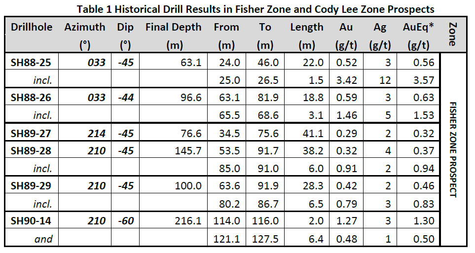
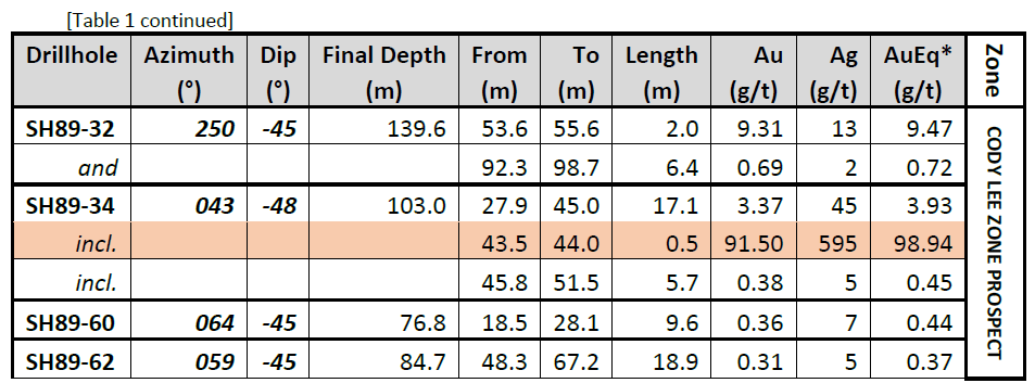
** Intervals are core-length weighted. True width is estimated unknown.
***Calculated composites are truncated to significant 2 digits for Au/AuEq and the nearest whole number for Ag.
SHASTA EAST
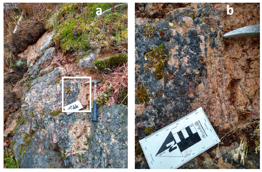
Although outcrop is poor in the area surrounding the Shasta main Deposit, exposures are present and detailed analysis of structural elements in these exposures has proved to be valuable guides to trends not previously recognized by past operators and which may control vein system development. A large east-northeast trending soil anomaly lies east of the Shasta main Deposit (“Shasta East”). Reconnaissance mapping and prospecting located the projected extension of the zone in outcrops to the west of the Shasta East historical soil anomaly, directly along strike and adjacent to the Shasta main Deposit. The intersection of this structure and the primary north-northwest trending JM Zone and north-south trending Shasta Zones may control higher grade mineralization within the main Shasta main Deposit. Figures 3a and 3b present a photo of potassium feldspar flooded, stockwork and sheeted quartz veined dacitic feldspar porphyry and a blow up of the inset to illustrate the style of alteration.
SOIL GEOCHEMICAL SURVEYS
Approximately 900 conventional B-horizon soils were collected in a series of grids east and west of the main Shasta main Deposit. Sparse, widely spaced historical reconnaissance style drilling in the 1980s and 1990s in these areas intersected scattered but significant intervals of disseminated sulphides, potassium feldspar alteration and epithermal veining. The widely spaced, shallow small diameter drilling was focused on probing for high grade veins suitable for underground mining operations which were the targets at the time. The 2022 program was designed to further advance these prospects to a drill stage.
GEOPHYSICAL SURVEYS
The geophysical surveys were completed August and September 2022. GEM systems GSM-19WMV magnetometers were used for the magnetics and VLF surveys. The surveys consisted of collection of magnetic readings, where magnetic field readings are measured once per second, and VLF readings, where readings are measured every 20 m (nominal). The total distance surveyed on the Shasta and Newberry grids is approximately 108 line-kilometres. Lines were spaced approximately 100 m apart with measurements taken on average on 20-metre centres along east-west oriented grid lines with periodic north-south oriented tie lines.
The geophysical data was post-processed using conventional data reduction techniques, filtered and gridded to produce a series of electronic deliverables. The surveys were of high quality and suitable for use for the purposes intended. The magnetic data illustrates several key elements in the local area around the Shasta main Deposit where outcropping bedrock exposures are sparse.
Five high priority, new prospects have also been identified which TDG believes merit follow-up exploration work to generate drill targets (see Figure 2).
- Location A. Prominent north-northwest trending magnetic high correlates directly with a several hundred metre wide x several metre long gold-in-soils and alteration zone at the Newberry Prospect which was identified by Newmont in their work in the 1980s. The magnetic high extends along strike to the south-southeast for another 800 m, but Newmont soil surveys did not cover this area. The alteration zone at Newberry remains open to the south, beneath a veneer of talus and is a compelling target to extend the Newberry anomaly.
- Location B. Situated in an area completed covered with glacial overburden, a sharp magnetic north-northwest trending magnetic gradient marks the eastern edge of the Duncan Pluton, part of the Black Lake Intrusive Suite which is the same age as the porphyry copper-molybdenum-gold deposits at the Kemess deposits to the south.
- Location C. Strong, circular magnetic high within a broader more diffuse magnetic high that may represent a volcanic dome or vent. Previous workers suggested the presence of a large shallow subvolcanic dacitic dome east of the Shasta area and field observations this season generally concur with that hypothesis, although further field work will be required to confirm this.
- Locations D and E. Distinctive northeast linear magnetic gradients are evident in the data and are likely faults. Smaller faults with northeast orientations were observed offsetting mineralized veins in the Shasta main Deposit Creek and JM open pits and are likely common throughout the area based on the VLF data including at the Newberry Prospect (Figure 4).
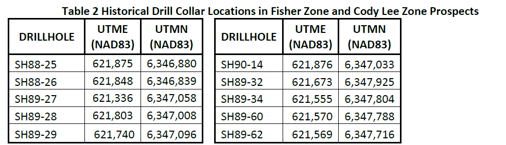
All historical core are NQ/BQ core size. Locations for historical drillholes are presented in Table 2.
Qualified Person
The technical content of this news release has been reviewed and approved by Steven Kramar, MSc., P.Geo., a qualified person as defined by National Instrument 43-101.
This news release includes historical information that has been reviewed by the Company’s geological team and qualified person. The Company’s review of the historical records and information reasonably substantiate the validity of the information presented in this news release; however, the Company cannot directly verify the accuracy of the historical data, including the procedures used for sample collection and analysis. There is insufficient exploration on these prospects to define a mineral resource. It is uncertain if after additional exploration a mineral resource will be delineated. Therefore, the Company encourages investors to exercise appropriate caution when evaluating these results.
The Cody Lee Zone has been renamed from the Christmas Creek Zone with the kind permission of his family, in honour and remembrance for Cody Lee whose tragic accident occurred at Shasta on October 05, 2021.
About TDG Gold Corp.
TDG is a major mineral claim holder in the historical Toodoggone Production Corridor of north-central British Columbia, Canada, with over 23,000 hectares of brownfield and greenfield exploration opportunities under direct ownership or earn-in agreement. TDG’s flagship projects are the former producing, high grade gold-silver Shasta, Baker and Mets mines, which are all road accessible, produced intermittently between 1981-2012, and have over 65,000 m of historical drilling. In 2021, TDG advanced the projects through compilation of historical data, new geological mapping, geochemical and geophysical surveys, and, for Shasta, drill testing of the known mineralization occurrences and their extensions. In May 2022, TDG published an initial NI 43-101 Mineral Resource Estimate for Shasta. For the 2022 field season, TDG is prioritizing drilling the known mineralization around Shasta. TDG currently has 96,343,142 common shares issued and outstanding.
ON BEHALF OF THE BOARD
Fletcher Morgan
Chief Executive Officer
For further information contact:
TDG Gold Corp.,
Telephone: +1.604.536.2711
Email: info@tdggold.com
Neither TSX Venture Exchange nor its Regulation Services Provider (as that term is defined in the policies of the TSX Venture Exchange) accepts responsibility for the adequacy or accuracy of this release.
This news release contains forward-looking statements that are based on the Company’s current expectations and estimates. Forward-looking statements are frequently characterized by words such as “plan”, “expect”, “project”, “intend”, “believe”, “anticipate”, “estimate”, “suggest”, “indicate” and other similar words or statements that certain events or conditions “may” or “will” occur. Such forward-looking statements involve known and unknown risks, uncertainties and other factors that could cause actual events or results to differ materially from estimated or anticipated events or results implied or expressed in such forward-looking statements. Such factors include, among others: the actual results of current exploration activities; conclusions of economic evaluations; changes in project parameters as plans to continue to be refined; possible variations in ore grade or recovery rates; accidents, labour disputes and other risks of the mining industry; delays in obtaining governmental approvals or financing; and fluctuations in metal prices. There may be other factors that cause actions, events or results not to be as anticipated, estimated or intended. Any forward-looking statement speaks only as of the date on which it is made and, except as may be required by applicable securities laws, the Company disclaims any intent or obligation to update any forward-looking statement, whether as a result of new information, future events or results or otherwise. Forward-looking statements are not guarantees of future performance and accordingly undue reliance should not be put on such statements due to the inherent uncertainty therein.