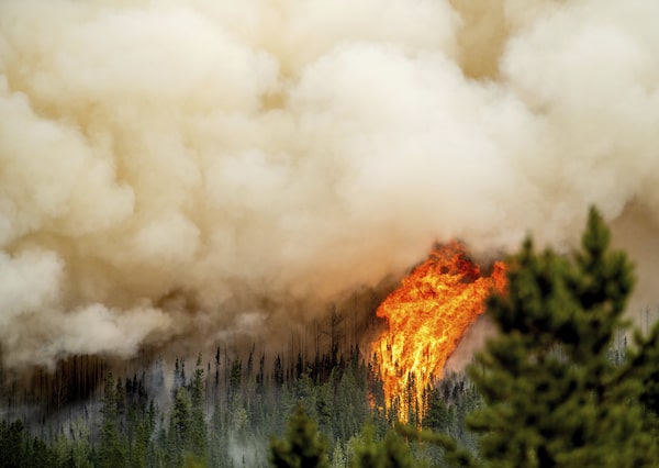
Flames from the Donnie Creek wildfire burn along a ridge top north of Fort St. John, B.C. on July 2. Canada's record-breaking wildfire season has now seen 100,000 square kilometres of land burned as fires continue to burn out of control across the entire country.Noah Berger/The Canadian Press
Canada’s record-breaking wildfire season has now seen 100,000 square kilometres of land scorched as blazes continue to burn out of control across the entire country.
The total area burned is roughly the size of Lake Ontario, Lake Erie and Lake Michigan combined.
Canada surpassed the record set in 1989 for total area burned in one season on June 27 when the figure totalled 76,000 square kilometres, and communities have faced evacuation orders, heat warnings and poor air quality for months.
The Canadian Interagency Forest Fire Centre says the majority of blazes are now in Western Canada, and British Columbia has the greatest number with 373 active fires.
Wildfire in British Columbia have prompted more than 70 current evacuation alerts or orders as of Sunday, with many clustered in the province’s central Interior.
The Cariboo Regional District issued an order this weekend covering 38 parcels of land in a 160-square- kilometre area around Anahim Peak, northeast of Bella Coola.
That’s on top of an order issued Friday spanning nearly 3,340 square kilometres in the Lhoosk’uz area, west of Quesnel, and several others in the area.
The Regional District of Bulkley-Nechako, meanwhile, has rescinded an evacuation order issued June 30 in response to the Big Creek wildfire. Residents of a remote area that includes Omineca Provincial Park may return home, although they remain subject to an alert and must be ready to leave right away.
The Peace River Regional District also cancelled an evacuation alert covering 60 properties due to the Donnie Creek blaze, the largest in B.C.’s history.
The alert had spanned a lengthy stretch of Highway 97, along with properties in a remote area north of Fort St. John, for more than two weeks.
Environment Canada continued to warn of smoky skies and reduced visibility on Sunday throughout central and eastern B.C. from the Yukon boundary to the Kootenays.
The weather office also posted severe thunderstorm bulletins for a swath of the central Interior, saying conditions were favourable for the development of storms that may be capable of producing strong winds, heavy rain and hail.
With more than 370 wildfires burning in B.C., the Canadian Interagency Forest Fire Centre said the province has the greatest number of blazes across the country.
B.C.’s drought bulletin shows widespread drought conditions, and fire danger rating is ranked at high to extreme across much of the province.
The Transportation Ministry has warned drivers not to pull over and stop to take pictures of wildfires, saying it’s “very unsafe” to do so.
A statement posted to Facebook says ministry staff have heard reports of people stopping along highways, especially Highway 16 between Prince Rupert and Prince George, a route where several “wildfires of note” are burning nearby.
There are 20 highly visible, threatening or potentially damaging blazes burning in B.C., many of which are clustered in the Bulkley-Nechako and Cariboo regions.
Based on forecasted conditions, Natural Resources Canada expects the wildfire season will continue to be unusually intense throughout July and into August.
Emergency Preparedness Minister Bill Blair says the good news is that conditions are expected to improve significantly in Eastern Canada.